

The Copernicus Sentinel-1 mission consists of two identical satellites orbiting the Earth in the same orbit, each scanning the entire surface every six days. Sentinel-1D was launched on November 4, 2025, at 10:02 p.m. CET (6:02 p.m. local time) on an Ariane 6-2 rocket from Kourou, French Guiana. After an overlapping operational phase, it will replace the Sentinel-1A satellite already in orbit. Together with Sentinel-1C, launched in 2024, they will form the new satellite pair. The German Aerospace Center (DLR), part of the German Federal Government, oversees the Copernicus program at the European level and supports its use in Germany through concrete measures. The radar instrument on Sentinel-1D was built by Airbus in Friedrichshafen. DLR institutes in Oberpfaffenhofen assist with the calibration of the radar instruments.
Copernicus is the largest and most successful Earth observation program in Europe. It consists of several parallel missions. The Sentinel-1 mission is equipped with a special radar instrument (SAR – Synthetic Aperture Radar) capable of producing high-resolution images. These images are acquired day and night, regardless of cloud cover, and cover the entire planet. Sentinel-1 images are essential for numerous applications in the global monitoring of land and oceans. Examples include climate change research, environmental management, disaster relief (such as in the case of floods), the detection of minute movements of the Earth’s surface, such as uplift, subsidence, and slow landslides, as well as the detection of oil spills and the movement of ships.
Data from the Sentinel-1 mission recently revealed that approximately 75 percent of global fishing fleets were previously invisible to public tracking systems. While not all vessels are legally obligated to transmit their position, ships not recorded in public monitoring systems can pose a challenge to the protection and management of marine natural resources and to maritime safety. Satellite data offers invaluable assistance in this area, as it does in many others.
Support from DLR
Teams at the DLR site in Oberpfaffenhofen are also involved in the commissioning of the satellite.
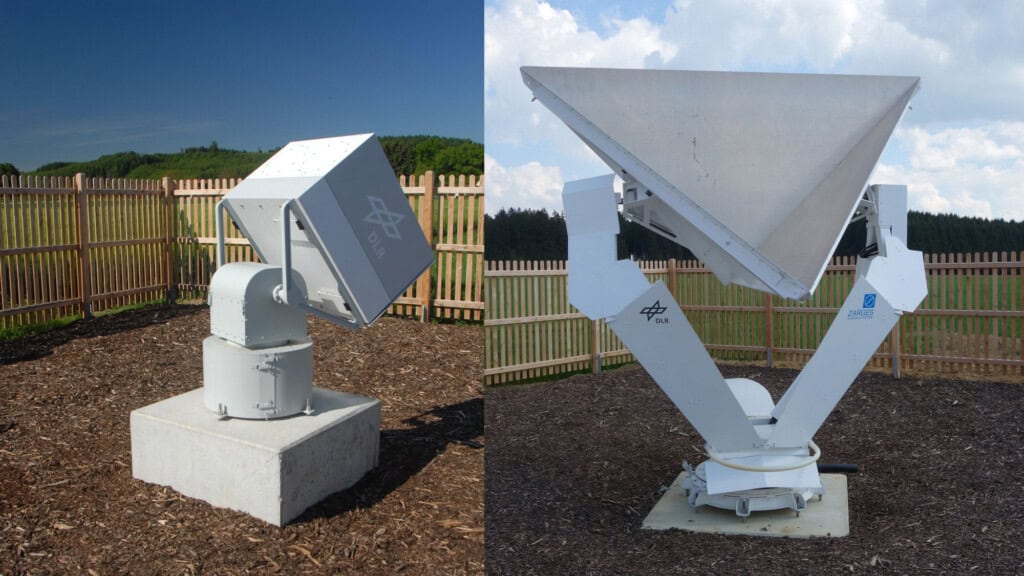
The DLR SAR Calibration Center at the DLR Institute of High Frequency Technology and Radar Systems has been the central calibration facility for Sentinel-1 since 2014. As with Sentinel-1A, -1B, and -1C, the Synthetic Aperture Radar (SAR) system on Sentinel-1D is calibrated from Oberpfaffenhofen after its launch. Following the satellite’s check-out and initial functional tests, the SAR instrument undergoes a meticulously planned measurement program. This program utilizes the highly successful concepts and methods of TerraSAR-X and TanDEM-X, which were further developed and improved in accuracy for Sentinel-1 by the DLR Institute’s calibration team. At the heart of the SAR Calibration Center are highly accurate remotely controlled reference targets, known as transponders and angle reflectors, which are distributed across a strip more than 100 kilometers wide west of Munich and operate as calibration standards.
The DLR’s Earth Observation Center (EOC) performs the geometric adjustment of the radar instrument using radar reflectors on the ground, checks its image quality, determines the noise level over calm and therefore dark-appearing sea surfaces, and ensures that the acquired radar images meet the very high requirements for interferometric data analysis. This is done both before the satellite is launched into space and throughout its entire lifetime.
| Interferometry |
|---|
| Interferometry refers to all measurement methods that utilize the superposition or interference of waves. These are typically light, sound, or, as in the example of Sentinel-1-D, radar waves. In this radar interferometry with Sentinel-1, two radar images taken from the same position but with a time difference are compared. From the slightly different distances to the same objects in the two images, minute movements of the Earth’s surface can be calculated. Monitoring such movements over a longer period allows for important conclusions to be drawn. For example, it can be determined where infrastructure is endangered by continuous ground subsidence, where mountain slopes are shifting, or whether supposedly inactive volcanoes might become active again. |